Self-Guided Audio Driving Tour in Zion & Bryce Canyon
Active
6h - 1d
For a full refund, cancel at least 24 hours before the scheduled departure time.
Instant confirmation
Mobile or paper ticket accepted
About this experience
The GuideAlong Audio Driving Tour takes you on an incredible journey through two of America’s most popular national parks.
Along the way you'll be guided to all of the area's famous highlights as well as lessor known gems including bucket-list hikes, a historic ghost town, and a top lookout across the entire Bryce Amphitheater.
This self-guided audio tour helps you discover more on your road trip with fascinating behind-the-scenes stories, local tips and directions that plays automatically along the drive.
Enjoy the freedom to explore offline at your own pace so you can spend more time at places that interest you, and bypass any that don’t.
✅ Stories, tips and directions play automatically based on your location
✅ Travel at your own pace
✅ Tour offline using GPS, no cell service or WiFi needed
✅ Suggested itineraries for half, full or multi day use
✅ Buy once, use forever! No expiry, includes free updates
Available options
Self-Guided Audio Driving Tour in Zion & Bryce Canyon
What's included
Support: Toll free phone, chat and email
Easy To Use: Pre-download and tour offline
Trip Planners: In-app, web and PDF
Buy once, use forever! No expiry, includes free updates
GuideAlong (GyPSy Guide) Audio Tour: 195+ Points
Location Based: Stories, tips & directions that autoplay
Flexible Routes: Suggested itineraries or create your own
Detailed itinerary
1
Stop 1
As the audio guides play commentary based on your gps location, you can create your own itinerary along the tour route to match your interests and schedule.
Or you can use our trip planners for our suggestions on half, full or multi day itineraries.
Some of the many highlights are listed below;
2
As the audio guides play commentary based on your gps location, you can create your own itinerary along the tour route to match your interests and schedule.
Or you can use our trip planners for our suggestions on half, full or multi day itineraries.
Some of the many highlights are listed below;
3
Stop 3
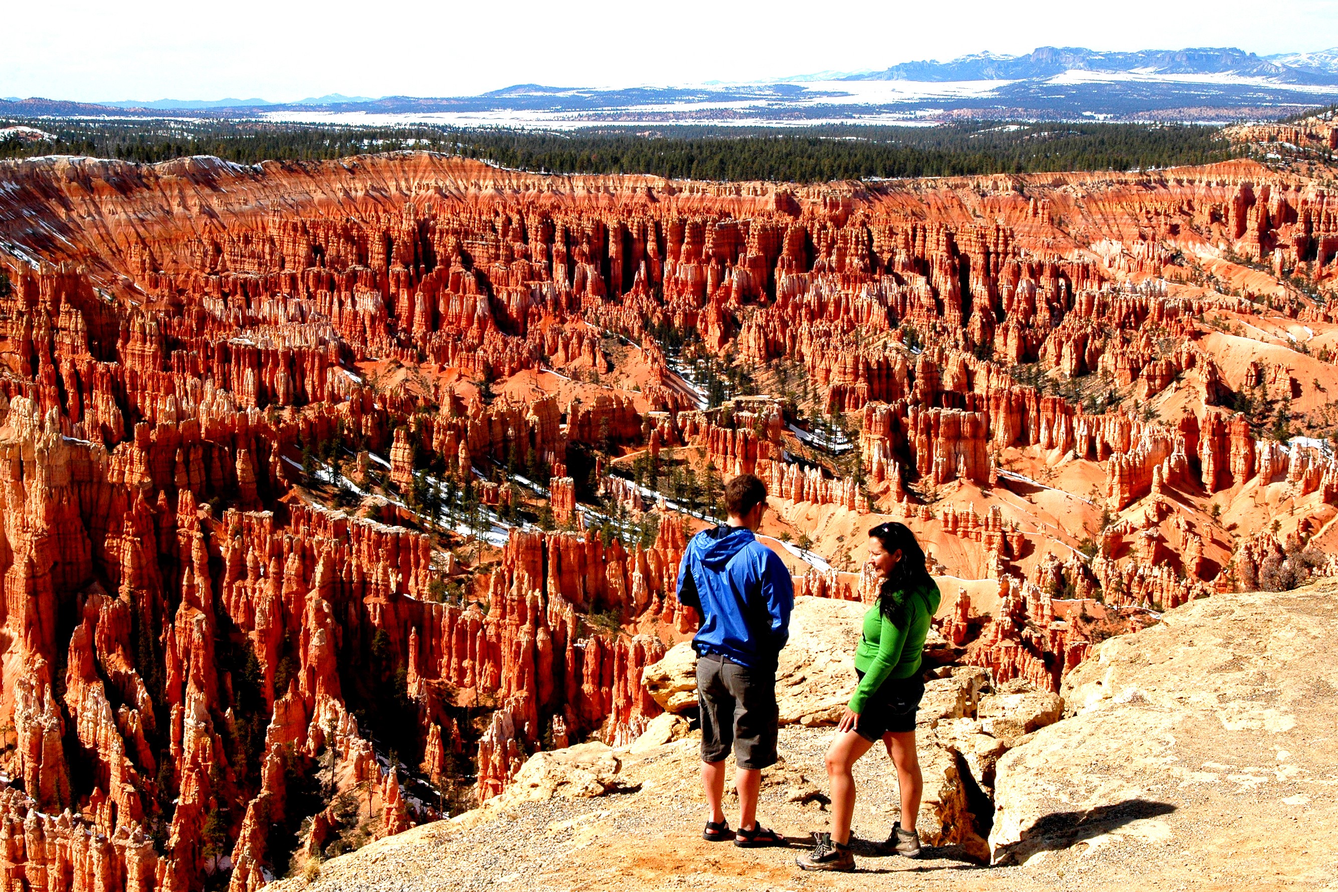
Inspiration Point is 3 different views combined into one. There are 3 tiers or platforms, each one climbing higher and opening new vistas down into what is called the Silent City.
From this location, it's especially easy to clearly see the different colors of the bands or stratas in the hoodoos - ranging from white to pink to rust colored.
4
Stop 4
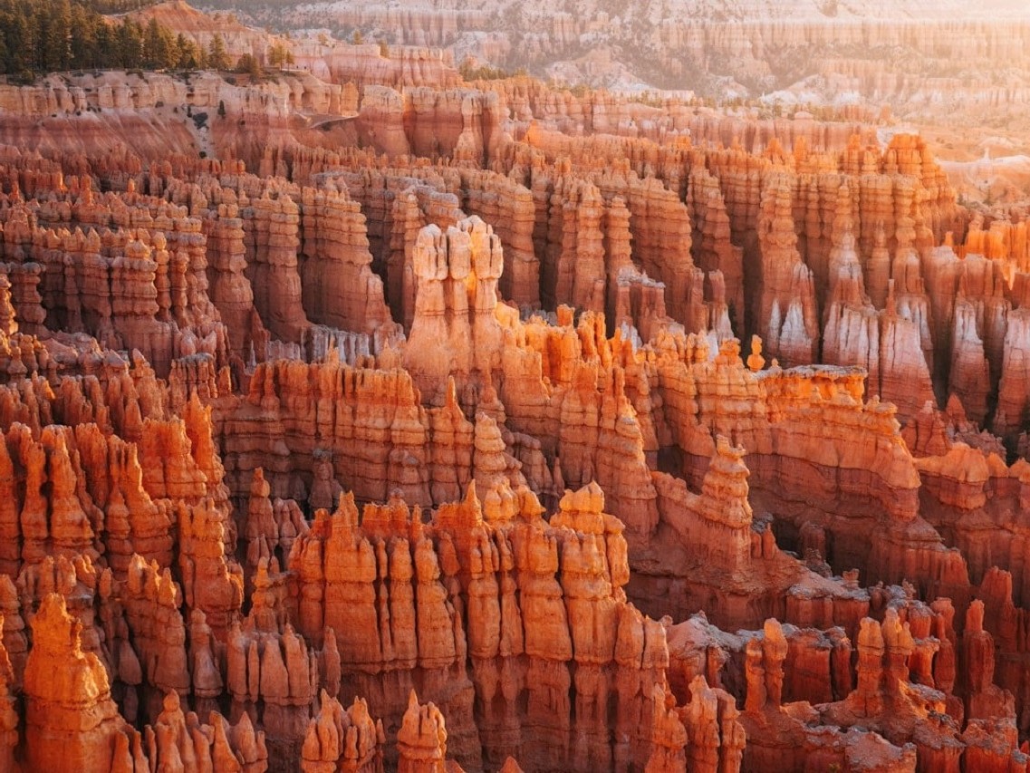
At Sunset Point, we are getting quite close to the hoodoos and can see details of the formation and erosion patterns. Individual formations have names like Thor's Hammer.
Sunset Point is the trailhead for one of the favorite hikes into the Amphitheater - the Navajo Loop Trail. The hike descends down below the rim and hikes can walk through formations like Wall Street and Two Bridges. The loop is 1.3 miles, but the trail is steep in places.
5
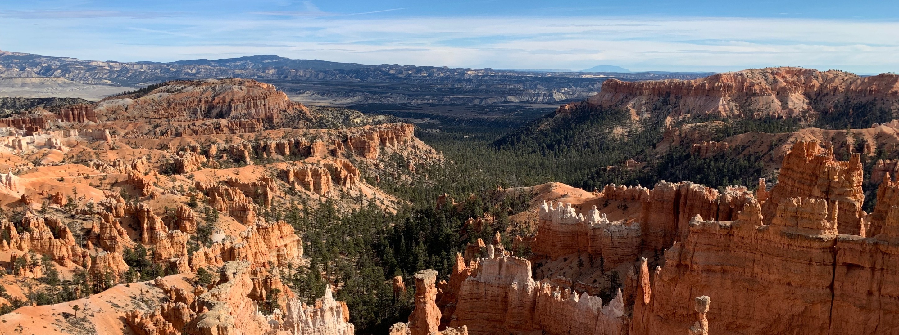
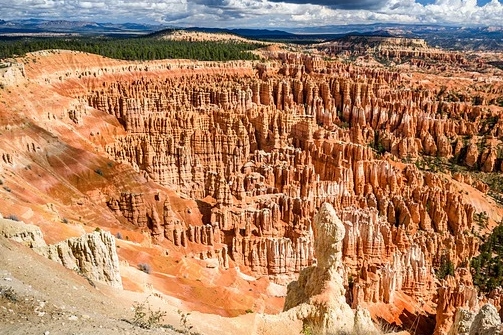
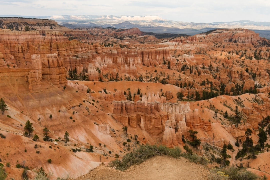
The greatest star of the Bryce Canyon National Park is of course the Amphitheater where visitors enjoy superb views of the hoodoo formations. Past the Amphitheater is the 18-mile Scenic Drive, which continues all the way to Rainbow Point, the highest and southernmost location in the park.
Along the drive there are at least 8 different pullouts and viewpoints that each share a different feature of the Park. You can choose to stop at some or all of them. Our favorites are Rainbow Point, Agua Canyon, Natural Bridge and Farview Point.
6
It's a subjective choice, but in our opinion this is the best place to take in your first views of the hoodoos, as it is located the furtherest away and provides the widest and grand views that captures the enormity of the Amphitheater.
This is the southern end point of the Rim Trail. If you want to walk the rim which will provide you with every view, you can park and start here, and then later catch the free shuttle to get back to your vehicle.
7
Stop 7
Located on the Zion Canyon Scenic Drive, Emerald Pools is a favourite hike that is not too strenuous, but walkers need to be capable of hiking roughly 60-90 minutes on an unpaved trail.
The first major highlight of the hike is the Lower Emerald Pool. What is so enjoyable here is that we actually walk behind the spray of the waterfalls in a cave-like overhang. The mist is refreshing and cooling.
Though subject to trail conditions, and the trail has been recently damaged and repaired, hikers can choose to continue on to the Middle and Upper Pools. The continuation of the hike is more strenuous than accessing the Lower Pool, so you can decide whether to continue or turn around. The trailhead is opposite Zion National Park Lodge, and that is the stop to use if the mandatory shuttle is in effect.
8
A short and fun diversion on Highway 9 between La Verkin and Springdale at the western entrance to Zion National Park, is to take the short drive to the Grafton Ghost Town. You can explore some of the old abandoned buildings, and visit the cemetery if you don't find that too creepy.
The tour will let you know where to turn off in the small town of Rockville, and then cross to the southside of the Virgin River for the 15 minute drive to the ghost town site.
9
Perhaps the best-known and most photographed landmark in East Zion is the Checkerboard Mesa.
This rock half-cone is characterized by horizontal and vertical cracks that give it that checkerboard appearance. There is a dedicated pullout and viewpoint for the best photos of this geological oddity.
10
Stop 10
Pass by
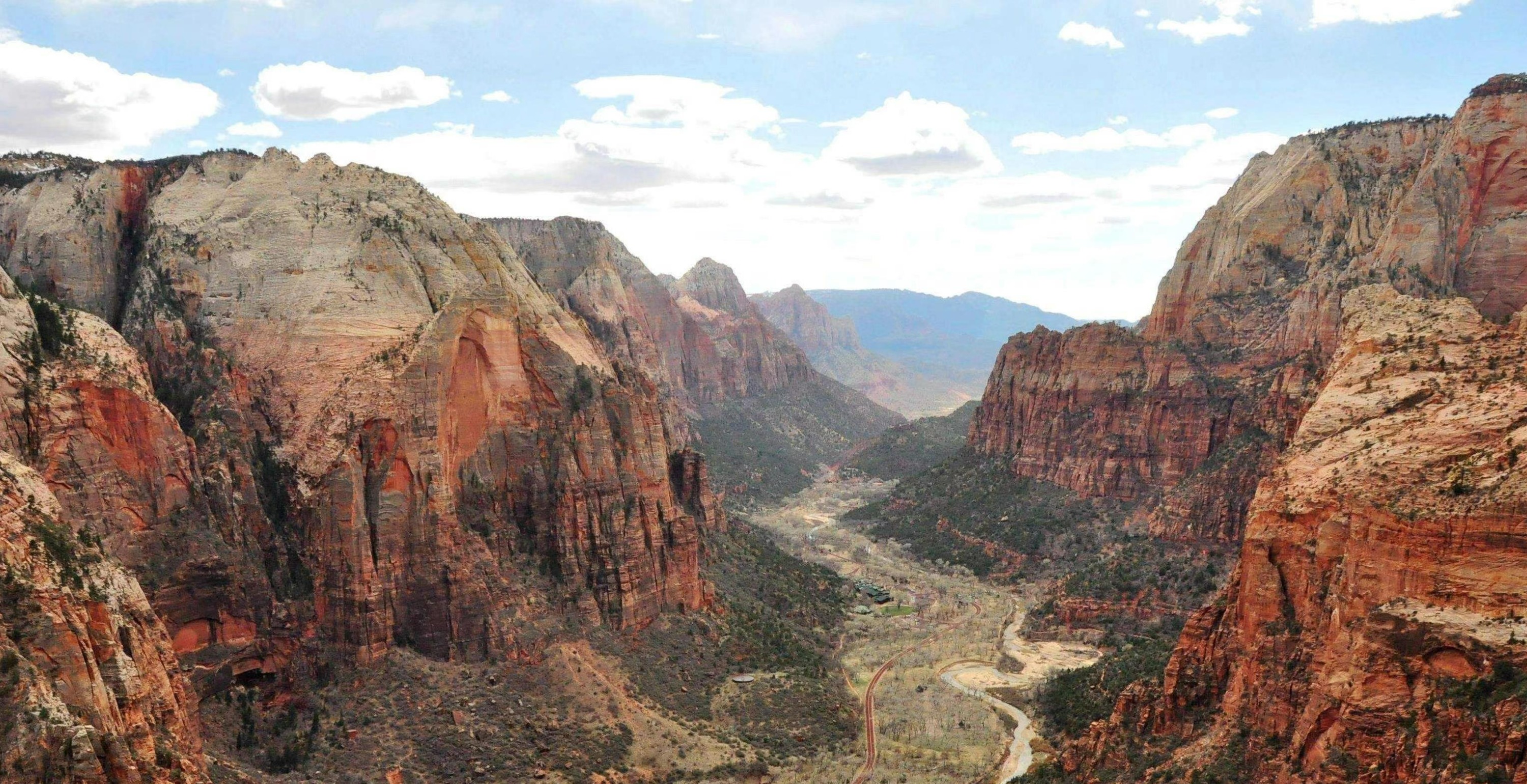
Driving all the way across the park, between the East and South Entrances, follows Highway 9. Short switchbacks help the road quickly climb 1000 feet of vertical rise. At the top of those switchbacks, road engineers had nowhere else to go, and so the Zion-Mt Carmel Tunnel was created for through traffic.
The tunnel is unusual in that it is only one lane wide, so it can only accommodate larger vehicles, like large RVs, in one direction at a time. Park Rangers have a system to get traffic through the tunnel - but you may need to exercise patience for this interesting part of the drive.
11
Most visitors to Zion will use the town of Springdale as their base for visiting the park. The town is located adjacent to the south entrance. Springdale is a full-service town with an excellent collection of hotels and accommodations, restaurants and cafes. Shoppers will enjoy the exploring the many galleries.
If you are planning the wade in The Narrows, there are outfitters in town that will set you up with all the necessary gear - which is usually best to rent.
12
Stop 12
At the end of the Zion Canyon Scenic Drive, we come to an area where we can enjoy the riverside walk, completely surrounded by Zion's magnificent vertical red rock cliffs. It's also called the Temple of Sinawava. Once we reach the end of the Riverside Walk - that's where the fun really starts. This is where The Narrows begins.
There's no reason to stop walking just because you've reached the Virgin River, from here the river itself become the trail. Hikers use the river to continue following the canyon, as the walls close in and become even more imposing.
The water tends to be chilly, so to do the Narrows, you wear wading gear, canyoneering shoes for better grip as you walk through the river, and a drysack to keep your valuables safe. And a sturdy walking pole is not just to complete the look, but helps stabilize you as you wade. Most average hikers will go 3-4 miles before turning back. Most of the time the water is only ankle deep, but it can get waist deep in some places.
13
Stop 13
This is a great stop along the Zion Scenic Drive Road. Just a short 1/4 mile uphill walk gets you to a lovely hanging garden and this is another location where you will be on the "inside" of a fine waterfall. Its definitely worth the 30 minutes or so that it takes to enjoy the experience.
There are 2 other popular hikes that require much more effort that depart from this location. Hidden Canyon is a 5-mile round trip to a hidden canyon - no surprise. The hike is quite exposed and iron chains are provided to help you stay on the trail in places. The toughest day hike in the Park also leaves from here, the 8-mile Observation Point hike climbs to the top of the mesa - rising 2150 vertical feet. Its a good workout!
14
Highway 12 joins Bryce Canyon National Park to Highway 89, which is the main route to connect Zion and Bryce. On 12, we will pass the Red Canyon.
You have the choice to join some interesting hikes here, but for most road trippers, the highlight is to stop and take photos of two short tunnels that have been carved through rock fins that allow the highway to pass through.
15
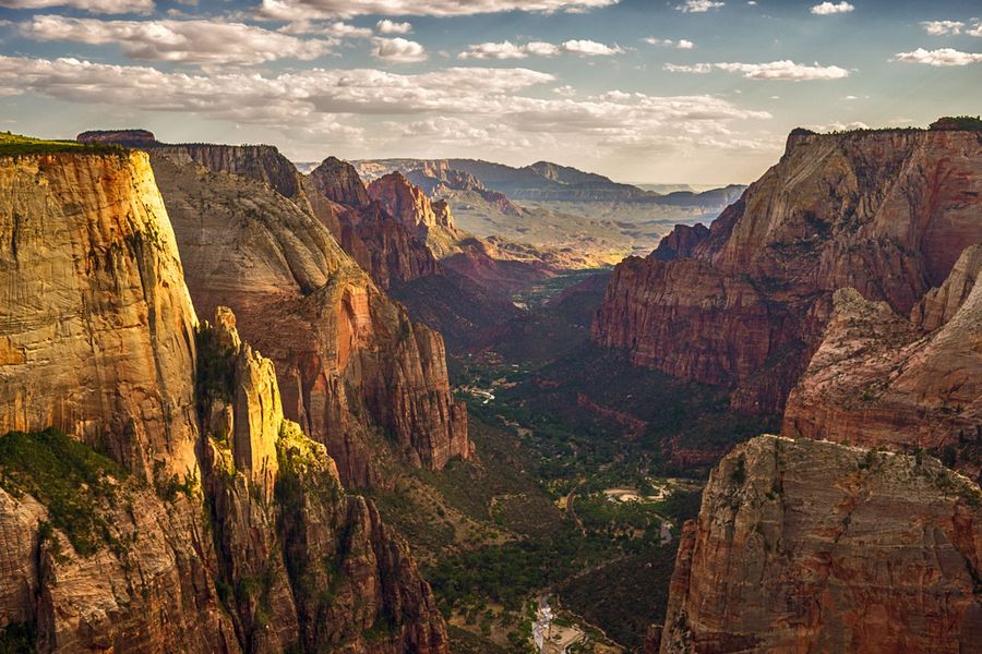
The Grotto Trail is an easy flat walk that many people enjoy as a way to stretch their legs and access the Zion Lodge. But this location is far more famous as the starting point for the challenging Angel's Landing hike.
That hike is only recommended for experienced and prepared hikers who are comfortable with heights. The most challenging section - mentally, is the crossing of a narrow ledge, 1,500 feet above the valley floor. The hike overall is 5-miles and requires significant elevation gain. It is so popular, that the trail can be downright crowded at times.
16
Stop 16
This is the viewpoint for the Amphitheater that is closest to the entrance for Bryce Canyon. Once again, we get to enjoy close up views of precariously balanced spires and formations that look ready to give up and collapse.
Those who want to hike into the Amphitheater will join the the Queens Garden Trail. This hike can be done as an out-and-back trail for 1.8 miles, or can be combined with the Navajo Loop trail to finish at Sunset Point.
There are countless amazing formations that you will enjoy on the hike, and you will want to stop for photos at some of the fairy-like doorways that take you right through some formations. The trail gets its name from a particular hoodoo that looks like Queen Victoria - that's no exaggeration!
What's not included
Entrance Fees
National Park Passes
Reservations
Available languages
Audio guide
EN
Reviews breakdown
Viator
4.3
9 reviews
5★
6
4★
2
3★
0
2★
0
1★
1
Tripadvisor
4.6
10 reviews
5★
9
4★
0
3★
0
2★
0
1★
1
Important information
Suitable for all physical fitness levels
How to Access: After booking you’ll receive an email and text with instructions (search “Download Audio Tour”). Click the link in the email/text to sign in with your preferred Apple or Google account and redeem your voucher code ahead of time
Download The GuideAlong App: Download the free app over WiFi or cellular data and sign in with the same Apple or Google account.
Download The Tour: Download the tour in the GuideAlong app under 'My Tours' over WiFi or cellular data.
Start The Tour: Open the tour in the GuideAlong app to preview the start locations, tour route and trip planner, or start the tour.
Location-Based Stories: Audio commentary plays automatically as you drive using your phone’s GPS chip. Wherever you are and whichever direction you’re going, you’ll hear the best stories and tips.
Flexible Travel Date: Tours are a one-time purchase with no expiry or date/time limit. If your plans change to a different day, there’s no need to change your travel date.
Tour at Your Leisure: With GuideAlong, you control the pace. Start, stop, and resume the tour any day, anytime, adapting it to your schedule.
Driving Tours: Group Savings: One purchase covers everyone in the vehicle, making it a cost-effective way to explore.
Works Offline: No internet or cell service is required once the audio tour is downloaded to your phone, so you can relax and tour offline.
Works Offline: No internet or cell service is required once the audio tour is downloaded to your phone, so you can relax and tour offline.
Bring Earbuds/Headphones: Bring earbuds to continue listening to driving tours on park shuttles and conveniently listen to walking tours.
Technical Support: The GuideAlong support team is available daily by toll-free phone, online chat, and email.
Meeting point
Start at (La Verkin, Widtsoe, Henrieville or Panguitch) or join anywhere along the tour route. After booking, search your email for “Download Audio Tour" and follow the instructions to download now over Wi-Fi/cell service. Then, preview the start location/s and tour route in the app.
Important notes
STEPS TO GET YOUR GUIDEALONG AUDIO TOUR:
1. SIGN IN + REDEEM your VOUCHER CODE: https://store.guidealong.com/voucher
2. DOWNLOAD the GuideAlong App
3. SIGN IN to the GuideAlong app with the same Apple or Google account as Step 1
4. DOWNLOAD the Audio Tour NOW
FIND YOUR VOUCHER CODE AND INSTRUCTIONS
- Email: Search your inbox for “Your Tour Operator Sent You A Message” and “Instructions for GuideAlong Audio Tour.” Check All Mail and your junk/spam folder.
- Text: Check for a text message from +17817732638.
- This Ticket: Find the voucher code at the top under the QR code and redeem at Step 1.
- Viator App: Open your booking and select Contact Support > Contact Tour Operator.
- TripAdvisor App: Open your Account and select Messages.
- Need help? Call GuideAlong toll-free on 1866-477-1791.
DOWNLOAD THE GUIDEALONG APP & TOUR NOW
You must pre-download both the GuideAlong app and audio tour to your phone over reliable wifi or cellular data before you drive out of signal. If you can OPEN your tour and see the START TOURING button, your tour is downloaded. No service is required while touring.
FLEXIBLE TRAVEL DATE
There’s no expiry, date or time limit for your tour, so download the GuideAlong app and audio tour now. If your plans change to a different day there’s no need to change your travel date.
CHARGING & SOUND
We don’t recommend connecting your phone to the vehicle's USB port. Instead, use a USB/C car charger adapter in the auxiliary power outlet (cigarette lighter) to prevent an automatic secondary pairing and keep your phone charged. CarPlay and Android Auto are not yet supported, so listen to the tour through your phone’s speaker or pair it to your car stereo via Bluetooth: guidealong.com/travel-tips-bluetooth/.
HELP & SUPPORT
- FAQs: Check the offline Help menu in the GuideAlong app or online FAQs at guidealong.com/faq.
- Contact GuideAlong Support: Call toll-free 1866-477-1791, chat online at guidealong.com, or email info@guidealong.com.
About Zion National Park
Zion National Park is a stunning natural wonder in southwestern Utah, renowned for its dramatic red rock formations, narrow slot canyons, and diverse ecosystems. It offers some of the most iconic hiking trails in the United States, attracting outdoor enthusiasts and nature lovers from around the world.
Top Attractions
The Narrows
The Narrows is a famous slot canyon where the Virgin River has carved a narrow gorge through the Navajo Sandstone. Hiking through the Narrows offers a unique and unforgettable experience.
Nature/Adventure
Half-day to full-day
Park admission required
Angels Landing
Angels Landing is a iconic hike offering breathtaking views of Zion Canyon. The trail features steep drop-offs and chain-assisted climbs, making it a challenging but rewarding experience.
Nature/Adventure
4-6 hours round trip
Park admission required
Emerald Pools Trail
The Emerald Pools Trail is a popular and relatively easy hike that leads to a series of beautiful pools and waterfalls. The trail offers stunning views of the surrounding canyon walls and lush vegetation.
Nature
2-4 hours round trip, depending on the route taken
Park admission required
Observation Point
Observation Point offers one of the most iconic and breathtaking views of Zion Canyon. The overlook can be reached via a strenuous hike or a shorter, less steep trail.
Nature
2-4 hours round trip, depending on the route taken
Park admission required
Kolob Canyons
Kolob Canyons is a lesser-known but equally stunning section of Zion National Park, featuring towering red rock formations, narrow canyons, and scenic drives.
Nature
Half-day to full-day
Park admission required
Must-Try Local Dishes
Green Chili Stew
A hearty and flavorful stew made with pork, green chiles, potatoes, and spices. It is a popular dish in the Southwestern United States and a staple in Utah cuisine.
Dinner
Contains pork, gluten (if served with bread or tortillas)
Navajo Tacos
A traditional Native American dish featuring fry bread topped with ground beef, beans, lettuce, cheese, and other toppings. It is a unique and delicious way to experience the region's culinary heritage.
Lunch/Dinner
Can be made vegetarian or vegan by omitting the meat and using plant-based toppings
Pioneer Chicken
A Southwestern dish featuring chicken breasts stuffed with green chiles, cheese, and spices, then breaded and fried. It is a popular dish in Utah and a must-try for those visiting the region.
Dinner
Contains gluten (breaded and fried)
Fried Pie
A sweet and flaky pastry filled with fruit, such as apple, cherry, or peach. It is a popular dessert in the Southwestern United States and a delicious way to end a meal.
Dessert
Contains gluten (pastry)
Popular Activities
Hiking
Canyoneering
Rock climbing
Mountain biking
Horseback riding
Scenic drives
Picnicking
Wildlife viewing
Best Time to Visit
Spring (March to May) and Fall (September to November)
Spring and fall offer pleasant temperatures and vibrant colors, making them the most popular times to visit. The weather is ideal for hiking and outdoor activities.
10-25°C (50-77°F)
50-77°F
Practical Information
Language
- Official: English
- Widely spoken: Spanish, Navajo
- English: Widely spoken
Currency
United States Dollar (USD)
Time Zone
Mountain Time Zone (MT), UTC-7 (Standard Time), UTC-6 (Daylight Saving Time)
Electricity
120VV, 60HzHz
Safety Information
Overall Safety Rating: Generally safe, but visitors should be aware of potential hazards and take necessary precautions
Zion National Park is generally safe, but visitors should be aware of potential hazards, such as extreme temperatures, steep drop-offs, and flash floods. It is important to stay on marked trails, carry plenty of water, and be prepared for changing weather conditions.
Important Precautions:
- • Stay on marked trails and follow park regulations
- • Carry plenty of water and snacks, as well as a basic first aid kit
- • Be aware of weather conditions and potential hazards, such as flash floods and steep drop-offs
Getting there
By air
- McCarran International Airport • 260 miles (420 km) from Zion National Park
- St. George Regional Airport • 60 miles (97 km) from Zion National Park
By bus
Greyhound Bus Station in St. George
Getting around
Public transport
The shuttle service is mandatory during peak season (spring through fall) and highly recommended during other times. It is a convenient and eco-friendly way to explore the park.
Taxis
Available • Apps: Uber, Lyft (limited availability)
Rentals
Car, Bike
Neighborhoods
Springdale
Hurricane
St. George
Day trips
Bryce Canyon National Park
83 miles (134 km) • Full day
Bryce Canyon National Park is another stunning natural wonder in Utah, featuring unique geological formations known as hoodoos. The park offers a variety of hiking trails, scenic drives, and breathtaking viewpoints.
Grand Staircase-Escalante National Monument
75 miles (121 km) • Full day
Grand Staircase-Escalante National Monument is a vast and remote area in southern Utah, featuring a variety of geological formations, slot canyons, and natural arches. The monument offers a unique and unforgettable experience for those willing to venture off the beaten path.
Antelope Island State Park
150 miles (241 km) • Full day
Antelope Island State Park is a beautiful island park located in the Great Salt Lake, featuring a variety of wildlife, hiking trails, and scenic viewpoints. The park is a popular spot for hiking, biking, and wildlife viewing.
Festivals
Zion Canyon Music Festival • June
Zion National Park Plein Air Festival • October
Springdale Art Walk • Monthly, on the second Friday of each month
Pro tips
- Arrive early to secure a spot on the shuttle during peak season
- Check weather conditions and trail closures before setting out on hikes
- Bring plenty of water and snacks, as there are limited facilities within the park
- Wear sturdy, comfortable footwear, such as hiking boots or trail shoes
- Consider hiring a guide or joining a guided tour for a more in-depth and safe experience
From $25
per person
Price varies by option
Secure booking
Free cancellation available
Instant confirmation