


Santa Ana volcano hike with privileged early access. Go safe and skip the crowds
Active
7h - 8h
For a full refund, cancel at least 24 hours before the scheduled departure time.
Instant confirmation
Mobile or paper ticket accepted
About this experience
Privileged early access in small groups
As Licensed Guide with 400+ successful summits you can be sure I'm one of the most experienced guides for this destination.
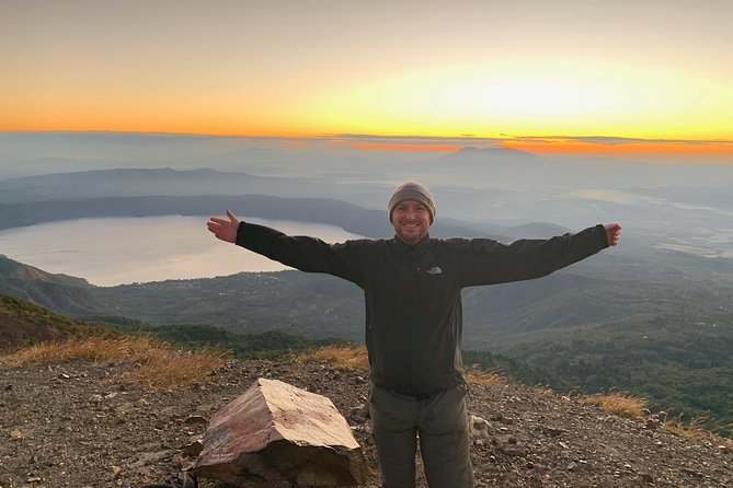
The hike goes from the cloud forest on the skirts to the volcanic wasteland at the top. From here you can see the steamy sulfuric-acid lake at the bottom and the multicolored layers of ash on the walls of the crater and Coatepeque caldera lake.
Beyond just a walk, this is an interpretative hike. Learn facts of geology, eruptive history, etc. of the volcanoes.
Skip the crowds, the warmest hours, the lines and the slow walkers and queues.
This is a private departure, not the 10 AM joint hike. This way you go your own pace, making the experience more enjoyable.
The larger the group the slower it goes. Even weather tends to be more favorable on early hours.
Seize more of your day! No hurries, no crowds. Enjoy the views, take pictures.
Looking for an extra challenge? Book for the longer hike to the summit of the volcano.
Available options
Hike a Trilogy of Volcanoes
Santa Ana, Izalco, Cerro Verde: This is one of the most challenging hikes: 3 major volcanoes in one day!
Do you dare? Not for the faints of heart.
<br/>Pickup included
Private Departure.Small Groups
Duration: 7 hours: At a glance
Distance walked: ~8 Km
Actual walking time: 3h30m - 4h
Elevation gain: ~450 m
Top elevation: 2278 masl<br/>San Blas Sector: This is the most used and easiest trail to the rim of the crater.
With early privileged access you skip the crowds.<br/>Pickup included
Reaching the very summit!
Duration: 9 hours: 5 - 6 hours of actual walking time along coffee farms, rural roads and a lush cloud forest and moorland on the summit.<br/>By Los Andes Sector: This is a 21 Km, less beaten track. A more challenging hike that takes you to the very summit of the mighty Santa Ana volcano<br/>Pickup included
What's included
Admissions to Natural Protected Area
Guided hike
Privileged early access for small groups.
Use of park's facilities
All Fees and Taxes
Air-conditioned vehicle
Hiking sticks available upon request
Detailed itinerary
1
Stop 1
Pass by
Parque Nacional Los Volcanes (AKA Cerro Verde) is a compound of 3 major volcanoes, including the tallest (Santa Ana) and the youngest in El Salvador (Izalco).
The lands in and beyond the Protected Area are habitat for one third of the known wildlife species in El Salvador and a mix of environments: from the coffee farms and solidified lava flows and from the lush cloud forest to the moorlands.
This Protected Area is one of the natural jewels of El Salvador.
2
With this privileged early access you skip the crowds, the warmest hours and waiting in line. You walk your own pace and spend more time enjoying by the crater.
Also called Santa Ana, this the tallest volcano in El Salvador and a terrific hike with stunning views to the valleys and Coatepeque caldera lake below. This is also the Easternmost peak of the majestic Apaneca mountain range, a belt formed by 14 volcanoes and the largest coffee country of El Salvador.
Along the hike we walk through diverse environments, from the cloud forest to wasteland on the top. A couple of miradores offer great views and a good place for a rest. Once on the top you can see the massive and deep crater with a steaming turquoise sulfuric-acid lake at the bottom and the fumaroles spewing sulfuric gas.
On a clear day from here you can see up to 9 volcanoes, the fertile Zapotitán valley and the Pacific Ocean coastline on the distance.
3
Stop 3
Enjoy a Salvadoran lunch in a restaurant sitting on the rim of the ancient caldera, overlooking Coatepeque, the most beautiful natural lake of El Salvador lying placid on the outskirts of the Santa Ana volcano.
From here you can point to that volcano and proudly say: "Veni, Vidi, Vici".
(Lunch and drinks not included)
What's not included
Personal expenses
Meals and drinks
Available languages
Guide guide
EN
ES
Reviews breakdown
Viator
5.0
1 reviews
5★
1
4★
0
3★
0
2★
0
1★
0
Tripadvisor
5.0
9 reviews
5★
9
4★
0
3★
0
2★
0
1★
0
Important information
Not recommended for travelers with spinal injuries
Not recommended for pregnant travelers
Not recommended for travelers with poor cardiovascular health
Travelers should have at least a moderate level of physical fitness
Meeting point
Carretera a Cerro Verde
About Santa Ana
Santa Ana is a charming colonial city nestled at the foot of the iconic Ilamatepec volcano, known for its rich history, vibrant culture, and stunning natural landscapes. The city offers a blend of traditional Salvadoran charm and modern amenities, making it a unique destination for travelers.
Top Attractions
Ilamatepec Volcano
Ilamatepec, also known as Santa Ana Volcano, is an active volcano offering stunning views and hiking opportunities. The summit provides panoramic views of the surrounding landscape.
Nature
Half-day to full-day
USD 5-10 for guided tours
Santa Ana Cathedral
This beautiful cathedral is a prominent landmark in Santa Ana, featuring impressive architecture and historical significance. It is a must-visit for history and architecture enthusiasts.
Historical/Religious
1-2 hours
Free
Jardín Botánico La Laguna
This botanical garden is a serene escape from the city, featuring a variety of plant species, walking paths, and a small lake. It's perfect for nature lovers and families.
Nature
1-2 hours
USD 2-5
Must-Try Local Dishes
Pupusas
Thick corn tortillas stuffed with a variety of fillings such as cheese, beans, or pork. Served with curtido (pickled cabbage slaw) and tomato sauce.
Main dish
Vegetarian options available (cheese and bean fillings)
Yuca Frita con Chicharrón
Fried yuca (cassava) served with crispy pork rinds, curtido, and tomato sauce.
Main dish
Vegetarian options available (without chicharrón)
Pan con Pollo
A popular Salvadoran sandwich filled with shredded chicken, vegetables, and mayonnaise, served on a crusty roll.
Sandwich
Can be made vegetarian (without chicken)
Popular Activities
Hiking Ilamatepec Volcano
Boating on Lake Coatepeque
Exploring Joya de Cerén
Visiting Jardín Botánico La Laguna
Picnicking by Lake Coatepeque
Enjoying coffee at local cafes
Exploring Santa Ana Cathedral
Shopping at Mercado Central
Best Time to Visit
December to April
The dry season offers the best weather for outdoor activities and sightseeing. The city is lively with various festivals and events.
22-30°C
72-86°F
Practical Information
Language
- Official: Spanish
- Widely spoken: Nahuat
- English: Limited
Currency
US Dollar (USD)
Time Zone
CST (UTC -6)
Electricity
120VV, 60HzHz
Safety Information
Overall Safety Rating: Exercise caution
Santa Ana is generally safe for tourists, but petty crime and pickpocketing can occur in crowded areas. Exercise caution, especially at night and in less touristy areas.
Important Precautions:
- • Avoid walking alone at night in poorly lit areas
- • Use reputable taxi services or ride-hailing apps
- • Keep valuables secure and out of sight
Getting there
By air
- El Salvador International Airport • 60 km
By bus
Terminal de Santa Ana
Getting around
Public transport
The local bus system is affordable and covers most areas of the city. Buses are frequent and well-used by locals.
Taxis
Available • Apps: InDriver, Taxis Express
Rentals
Car, Bike, Scooter
Neighborhoods
City Center
Metapán
Day trips
Joya de Cerén
30 km • Half-day
A UNESCO World Heritage Site, Joya de Cerén is a pre-Columbian Maya farming village preserved under volcanic ash, offering a unique glimpse into ancient Mayan life.
Lake Coatepeque
20 km • Full-day
A stunning volcanic crater lake surrounded by lush landscapes, offering a variety of water activities and relaxation options.
Festivals
Feria de las Flores • July
Fiestas Patronales • July 26
Pro tips
- Visit the Santa Ana Cathedral early in the morning or late in the afternoon to avoid crowds and enjoy the peaceful atmosphere.
- Hike Ilamatepec Volcano with a local guide for a safer and more informative experience.
- Explore the local markets, such as Mercado Central, for authentic souvenirs and a taste of Salvadoran culture.
- Try authentic pupusas at local eateries, such as La Casa de las Pupusas, for a true taste of Salvadoran cuisine.
- Attend the Feria de las Flores (Flower Festival) in July for a vibrant and colorful celebration of the city's floral heritage.
From $25
per person
Price varies by option
Secure booking
Free cancellation available
Instant confirmation